Showing posts with label national parks. Show all posts

Monday, November 7, 2011

Entomological Expedition


We were two, and then we were one. In mid April, R. had to leave India - a.) because his visa was about to expire, and b.) because he got an awesome job leading a fur seal research project on a remote Alaskan island, and hey, if you've got to work now and then to make some money, you might as well be roaming rugged island cliff-tops, observing seals and racking up your bird life-list.  So he left, and I was sad.  But being a resilient climate change adaptation researcher (haha - resilient?  Climate change?  Get it?) I decided what better way to recover from my moroseness than to participate in an entomological research expedition in a remote national park in northern India!

At the Fulbright conference back in March I made the acquaintance of a Fulbright Senior Scholar, an entomologist and evolutionary biologist who was planning a bug-collecting expedition in the middle Himalayas in collaboration with the Wildlife Institute of India (WII). I jumped at the invitation to return to my biological field researcher roots and participate. So it came to pass that on a humid morning in early May I arrived by auto-rickshaw at the Dehradun headquarters of the Institute to meet the field team.

The next day the entomologist, three PhD students from WII and I traveled by land rover from Dehradun north into the Himalayan foothills. The first town we passed through was Mussourie, the place where I spent my first three months in India doing language study. We stopped only long enough to buy bananas, however, and then continued out of town down the road towards Kempty Falls.  The landscape became more densely forested, the terrain steeper. For eight very uncomfortable hours we navigated rural,bumpy roads, dodging the occasional bus and shared land rover taxi. Finally, as darkness began to fall, we arrived at a Forest Department lodge on the outskirts of Govind National Park in the far north-west corner of Uttarakhand state. I stumbled out of the land rover, lay down in the grass, and attempted to un-scramble my internal organs from the long ride.

After a quick drive to the trail head the next morning we were off, hiking a well-used trail connecting villages farther up the road-less valley.  In addition to me and the four researchers, we were accompanied by six porters from the village near the trail head. These very personable and enthusiastic young men were a pleasure to hike with - not only did they without fail produce delicious meals at our every improvised campsite, but they listened with serious expressions to my garbled Hindi without ever once rolling their eyes.

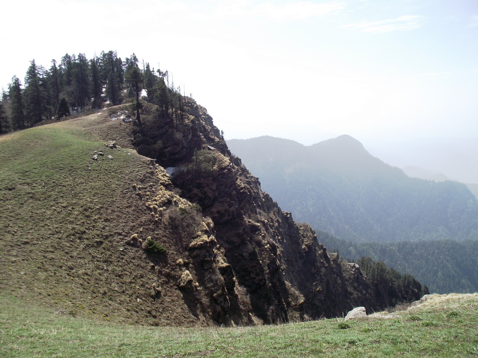
Four days later we staggered out of a cold and snow-crusted forest onto a sunny grass-covered hilltop above the treeline. The mountains of the middle Himalaya rose to the north against the vivid blue sky. Even at this altitude purple rhododendron bushes gave color to the hillsides, and we briefly spotted a yellow pine martin cavorting on a lower slope. Everyone dug their cell phones out of deep pockets, hoping to catch the signal that was inaccessible further down the slope.  

We didn't discover any entomological marvels, but got a close look at a beautiful and rarely visited corner of the country. This hilly land in the northwest of Uttarakhand is known as the Garhwal. Garhwali and Hindi are the main languages spoken in these parts, as well as mountain dialects from the neighboring state of Himachal Pradesh. Several times on the road we passed migrant Gujar people, grazing their buffalo in the high mountain pastures to escape the sudden spring-time heat on the plains to the south.

Garwali traffic jam
These land rover taxis fit 12 inside and another 5 on the roof!
Skull of a langur monkey, found along the trail


Local women out gathering fodder

 Garhwali orthoptera

Mountain rhododendron
Lepidoptera

Yellow pine martin
Chapattis for dinner!
Himalayan porcupine quills


Tuesday, October 11, 2011

The Gulf of Mannar: Conservation and Exploitation

Wandering the beaches in southern Tamil Nadu is an eye-opening experience. It's a beach-comber's delight - or nightmare, depending on how squeamish you are.  Broken woven baskets encrusted with dried fish detritus, coils of abandoned fishing net, the severed heads and tails of puffer fish and stingrays, and, least appealing, ubiquitous cow pies - or what would be called cow pies if they were made by cows and not people. Millions of fish corpses lay spread on the sunbaked earth, slowly drying in preparation for the fishmeal market. The acres of scaly bodies are so salty, so dry, that not even the black and grey Indian crows perched on the rooftops are tempted by them.

The beaches of the Gulf of Mannar biosphere reserve are not exactly what I expected. Being the starry-eyed, naive conservationist that I am, words like "biosphere reserve", "community-based conservation", and "UNESCO" make me think of tidy landscapes, prosperous people, and sustainable natural resource use.  Let’s just say that there is still some work to be done in the Gulf of Mannar.

In India the designation "biosphere reserve" has no legal status.  So the waters lapping at these busy and littered beaches have no more protection than any other piece of coastal water. However, areas with the biosphere reserve label do get a little more attention and funding than the average chunk of landscape crying out for a little conservation. 


The Gulf of Mannar was the first marine biosphere reserve in south-east Asia. These coastal waters of Tamil Nadu are extensively studied and support between 3,600-5,000 different species, making it one of the richest coastal regions in Asia.  Although fishing is allowed in the reserve, it is not allowed in the core area, the Gulf of Mannar marine national park, which encompasses the waters 500 meters offshore a series of small islands stretching down the coast.  National park is a much more rigorous management category than biosphere reserve. The wildlife warden of the national park and personnel from the Forest Department work together to manage human impacts in the area.

There is no doubt that the Gulf of Mannar is heavily over-fished. Illegal exploitation even occurs within the national park. Buoys were recently installed to delineate the edges of the protected area, but local fishermen quickly cut them loose to prevent strict enforcement. At the time of my visit state elections were only a few weeks away. In a triumph of political expediency over law enforcement, the incumbent politicians were deliberately refraining from enforcing the boundaries of the national park until after the elections in an effort to please voters.


In Ramanathapuram I met with an employee of the Gulf of Mannar Biosphere Reserve Trust, a public-private partnership organization working on sustainable development and livelihood issues in the national park and biosphere reserve.  He described to me the incomplete regulatory framework governing India’s fisheries and marine resources.  The Marine Fishing Regulation Act focuses entirely on the economic aspects of fishing and has no conservation focus.  Lack of enforcement is also a problem. Although regulations state that fishing net mesh size should be no smaller than 5cm, mesh sizes of 1.5-2 cm are common. Although the waters between the shoreline and 5km offshore are reserved for artisanal fishing, commercial trawlers commonly operate within the 5km limit.  Fishermen have been trained (and are required) to use turtle exclusion devices (TEDs) and juvenile (fish) exclusion devices (JEDs), but commonly use neither, as these technologies can cause them to lose 12-15% of their catch, a loss they are not prepared to endure. Because most trawlers are owned by rich businessmen living away from coastal fishing communities, the economic benefits of fishing are often not experienced by local fishermen. The cost of a trawl fishing boat is in the range of 30 lakh rupees (3 million dollars), far beyond the reach of actual fishermen. These rich trawl owners are politically well connected, ensuring nothing has been done to make trawl fishing more sustainable in over two decades.  An additional complication in this region is the narrowness of the exclusive economic zone between India and Sri Lanka. The waters are shallow with ever-changing patterns of sedimentation, forcing fishing boats to sometimes stray into the other nation’s waters. 

But despite these issues, in some ways the Gulf of Mannar biosphere reserve is a model for public-private conservation partnerships and innovative programs.  The Gulf of Mannar Biosphere Reserve Trust, jointly funded by the Government of India and the Global Environment Facility (GEF), runs a number of programs in rural fishing communities in coastal Tamil Nadu.  One major focus is capacity building. In the last several years almost 250 eco-development committees, each serving between 5-20 villages, have been developed. These committees manage microcredit programs, administer small grants for alternative livelihood training, and educate youth.  The Trust promotes some alternatives to fishing such as jasmine and betel leaf cultivation, making charcoal, palm jaggery, plaster of paris dolls and idols, salt, and shared autos.  It was also instrumental in getting plastic bags banned in the region, installing public, pay-to-use toilets, and building a centralized fish market to allow better communication between fishermen and better hygiene and display of the catch.   One major success of the Trust’s programs has been to eliminate high interest rate money lenders by starting its own low interest micro-credit scheme.

Additional threats to the Gulf of Mannar biosphere reserve are untreated sewage, nearby industrial plants releasing effluent, and over-harvesting of seaweed from the shallow waters around islands in the reserve.  Dynamite and cyanide fishing and coral mining have been completely stopped thanks to the work of the Trust.


Thursday, September 22, 2011

The Far South

Our last destination in India’s south was the Gulf of Mannar biosphere reserve.  This reserve, the first marine biosphere reserve in all of south and central Asia, encompasses 10,500 sq km of coastal waters stretching 300 km along the south-east coastline of the state of Tamil Nadu just opposite from the western coast of Sri Lanka.  Within the biosphere reserve are 21 small uninhabited islands scattered in a line parallel to the coast.  The water within 500 meters of these islands comprises the Gulf of Mannar marine national park, as well as the core area of the biosphere reserve. 
  
From the town of Ramanathapuram on the Indian mainland we travelled south-east down the length of a sandy peninsula which soon broke into a series of sand bar islands linked with bridges stretching towards Sri Lanka. At the south-eastern end of the last island is the Hindu pilgrimage town of Rameswaram, visited by worshipers of both Vishna and Shiva.  Home of both the Ramanathaswamy Temple and ghats for ocean bathing, Rameswaram is considered one of the holiest pilgrimage sites for Hindus in India and is sometimes called the “Varanasi of the south”.  

South of Rameswaram stretches a narrow spit of sand known as Adam’s Bridge.  About 10 km from town the spit disappears underwater to form a series of partially submerged limestone shoals connecting India and Sri Lanka.  Geological evidence and temple records indicate that Adam’s Bridge may have been passable on foot as recently as 1480, when it was destroyed by a cyclone.   The first mention of the bridge was by its other name, Rama’s Bridge, in the ancient Indian Sanskrit epic Ramayana, which refers to a bridge built by Lord Rama’s army of ape-men to allow Rama to reach the kingdom of Lanka (Sri Lanka) to rescue his wife, Sita, from a demon king. This compelling story notwithstanding, geological evidence tells us that the bridge is a natural geological formation, not man- (or monkey) made.

A 19th century painting depicting a scene from Ramayana in which monkeys and bears are shown building a bridge to Lanka. This painting is currently in the Philadelphia Museum of Art. Image from Wikipedia Commons.

The small town of Rameswaram is full of guest house accommodation for Indian religious tourists and every day in the early morning hundreds of pilgrims make their way down to the ocean-side bathing ghat.  The low morning sun picks out bright saris in a hundred hues as women wade into the sea fully dressed to perform their ablutions. On the shore vendors sell puja offerings – coconuts and marigolds in baskets made of woven leaves. Young men point their cell phone cameras at us as we try but fail to blend into the crowd.  Down the beach a pig roots in a rotting pile of sea flotsam and beyond a rocky seawall several men defecate on the beach.  Hundreds of moored fishing boats line the horizon, inactive due to the strictly enforced fishing ban observed in Tamil Nadu and Kerala from April 15th to June 1st.  During this time, changing water current patters result in a nutrient bloom that feeds young fish and is critical in ensuring continuing fish stocks.  Because of the seasonal ban, the beaches and wharfs are crowded with men, either engaged in repairs of nets and boats or resting under the shade of their boats drawn up onto the beach. 

We wander the shore, speaking with fishermen, admiring the catch of small boats not affected by the ban. Eventually we are driven by hunger and the heat of the rising sun into a small dhaba in search of breakfast.  South Indian parottas were on the menu – flaky flatbread beaten just a little bit to separate the layers. Sitting right next to the cooking station, every few minutes our table shook with a bang bang bang as the cook slammed his fist down repeatedly on a pile of fresh parottas. Waving away the flies, we consumed parottas and omelets from broad banana leaf plates, and then staggered home to nap during the heat of the south Indian afternoon.